Camera path generation using building height, volume, irregularity and uniqueness
A method to compute an "interest value" for candidate camera viewpoints in a 3D urban scene by scoring buildings visible from each viewpoint using building height, volume, geometric irregularity and a uniqueness metric, then synthesizing those building importance scores into a viewpoint interest value and deriving camera trajectory parameters from the interest values. The output is a camera trajectory (positions, orientations and implied speed profile) used to navigate through the 3D scene; target users are systems that auto-generate flythroughs or guided navigation in city-scale 3D models (map viewers, virtual tours, simulation tools).
(57) What the patent covered
This write-up was generated by AI from the patent's text and may contain mistakes, so check it against the original patent before relying on it.
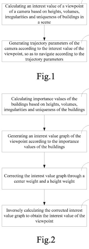
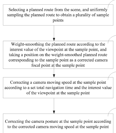
The independent claim requires computing, for a camera viewpoint corresponding to a camera position in a 3D scene composed of multiple buildings, an importance value for each building visible from that viewpoint based on building heights, volumes, irregularities and uniqueness; processing those importance values into a single viewpoint interest value; and generating camera trajectory parameters from the viewpoint interest values to control navigation.
Distinguishing feature: The viewpoint interest value explicitly combines building height, volume, geometric irregularity and a uniqueness measure per building, and uses that aggregated score to drive trajectory parameter generation including movement speed.
Novelty 3/5. Viewpoint scoring and automated camera paths existed (entropy, visibility, curvature); this patent combined multiple geometric building metrics and a uniqueness feature as the scoring input to generate trajectories.
Implementation
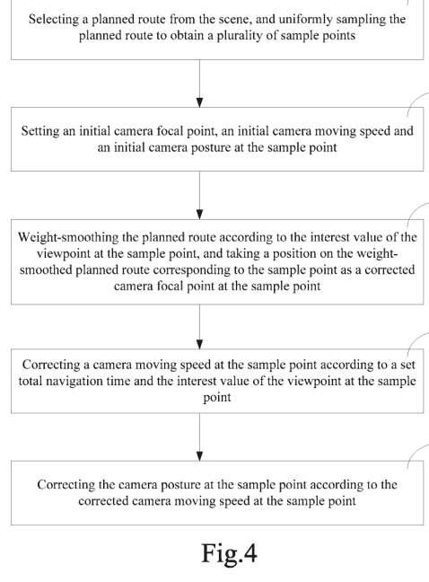
A small team would ingest a 3D building dataset (CityGML, glTF, or OBJ + attributes), rasterize or ray-cast per-candidate viewpoint to find visible buildings, compute per-building features (height from roof and ground, approximate volume from footprint×height, irregularity from facade curvature or polygon complexity, uniqueness as a rarity score across the scene), aggregate weighted importance values into viewpoint scores, sample high-interest viewpoints into a graph and compute a smooth path (Catmull-Rom or cubic Hermite splines) with speed modulation proportional to local interest; implement in a game engine (Unity/Unreal) or WebGL with a Python/Node backend for preprocessing.
Components: 3D city model (meshes or buildings as polygons with height/volume attributes), visibility/occlusion module (frustum culling, occlusion queries), building feature extractor (height, computed volume, irregularity metric, uniqueness metric), camera path planner (trajectory generation and speed modulation).
Buildability 5/5. The implementation requires standard 3D data, visibility routines and spline-based path generation; the main effort is engineering (preprocessing and tuning weights) rather than novel algorithms.
Market demand
Comparable products exist; none doing exactly this was found. There are several commercial and academic tools for editing or generating camera paths in 3D environments, including fly-through generators and route-based visualization. However, few publicly market products claim explicit, building-importance-based viewpoint scoring as described; most offerings provide manual path authoring or heuristic-based automation rather than a scoring model tied to building geometry metrics.
- Pegasus - Fly-through & Cutscene Generator · Procedural Worldsunknown
- City Recorder: Virtual City Tour · Toronto Visual Computing / academic release (City Recorder concept)unknown
- CineMap — Turn your routes into cinematic 3D flyovers · CineMap Studiounknown
Demand check by web search, week of Oct 12, 2026. Listings change frequently.
Buyers: Map viewers, virtual tour providers, simulation and training platforms.
Before manufacturing
No related continuation or divisional patents in force were found. Design patents, trademarks and unrelated patents may still cover the product.
Patent lapsed; practical risks are tuning the feature weights, handling noisy or incomplete building data, and existing academic work on viewpoint entropy and visibility that addresses similar goals.
About 1.5% of lapsed patents are later revived by their owners. This page is a research lead, not legal advice. Obtain a freedom-to-operate opinion before manufacturing.